
Neuse River Trail: Anderson Point Park to Skycrest Dr.
Trail Location:

Anderson Point Park | Raleigh, NC
Trail Distance:
7.7* miles (out & back)
Trail Difficulty:
Easy
Elevation profile & map >>
See the Raleigh Parks and Rec. map >>
* approximate distance
Here are some snippets from the project description on the RaleighNC.gov website:
...This trail will begin at Falls Lake Dam and will extend along the river to the Wake County line, a distance of 28 miles.
The Neuse River Trail project is divided into several segments for the purposes of awarding construction contracts.
Construction is scheduled to begin after the completion of the design of each segment with final completion of the project scheduled for late 2012.
According to the Raleigh Parks and Recreation Department's plans, this trail review will be partly obsolete by 2014, because they intend to pave the entire Neuse River Trail (Pavement disqualifies a trail from being a trail. My rules). A recent article indicates that the paving of segment three will take place sometime this year. So, if you prefer dirt and mud to asphalt and dodging bikes, get out there before paving begins.
 Currently, though, the Neuse River Trail surface is mostly comprised of groomed dirt over a trail wide enough to accommodate standard-sized vehicle traffic. The trail terrain is primarily flat and easy to run with just a couple of beastly hills in the middle of the course to make things interesting. The north side of the trail turns into a single-track, technical path; which is probably the highlight of the whole 3.9 miles (point to point).
As the name implies, the trail follows the Neuse River. So, you'll have some pretty nice views of the water during your run. And, the sound of rushing water in certain spots along the way is definitely a plus. It's not uncommon to see deer staring at you from the forest's edge.
The Neuse River Trail doesn't exactly put you out in the middle of untamed land, though. You'll pass a couple of housing developments along the way. And, Hwy 64 crosses the river around mile 1.5 from the park. So, don't worry about getting lonely out there.
Running the Trail
I run this trail pretty frequently, because it is convenient to where I live. The trail measures roughly 3.9 miles in one direction from the Anderson Point Park parking lot to the "trail end" marker. Obviously, it would be silly to run less than four miles point-to-point. So, you should plan to run this trail out and back, making your run a total of around 7.7 miles. It's a good way to spend an hour on a nice day when you can't make the trip to Umstead or Falls Lake.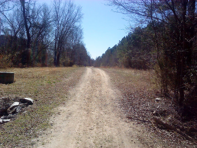
Starting your run on the gravel path from the parking lot at Anderson Point Park (the first parking lot before the bridge), you'll turn left after a few meters and see the trail head marker. The river will be on your right as the trail rolls up and down before leveling out for a while.
A couple of wooden bridges add variety to your footing as the trail itself shifts from crushed gravel to hard-packed dirt. After a decent rain, the Neuse River trail becomes especially muddy in some spots.
You'll continue along the path at a comfortable pace, cross beneath the Hwy 64 bridge, and keep going until the trail turns left through a swampy corridor of trees. If there were alligators to fear, this would be the spot to be cautious.
A paved road intersects the trail now. Don't worry. Just turn right onto the road and continue running. Make your first left up a short, steep hill—no shame in hiking this one. Then turn right onto the gravel trail. Goodbye pavement.
 Not the actual dachshund.
After a mile of the wide path behind Hedingham, the trail becomes more technical and narrower with some decent tree cover. This is the best part, of course. Sadly, though, this root-ridden, sometimes rocky section extends for only about a quarter of a mile before leading you to the trail's end. But, on the bright side, you get to turn around and run the technical section all over again!

My Favorite Features of the Neuse River Trail (Segment 3):
- that technical section towards the end (middle if out and back)
- Flat or slightly rolling terrain makes for a predictable workout.
- the river
- one or two relatively challenging hills
- convenient location for those of us living on the east side
Features I Dislike:
- Housing developments detract from natural beauty.
- flatness can be boring sometimes
- A dearth of tree cover and humid conditions make running the trail in Summer months unpleasant.
Getting There
I prefer to drive to Anderson Point Park (map) and start at the first parking lot. If you cross the bridge over the highway to park in the lot directly beside Anderson Point, you've gone out of your way. Starting near the park affords you the opportunity to use the restroom or fill a water bottle.(Okay, fine, you'll have to walk or run across the bridge to the facilities if you park where I told you to park. Use this as a warm up. You could use the entire paved park path as a warm up, too. I just like parking in the first parking lot, because I don't always have to use the restroom. But, if you'd rather be closer to the facilities than the trail head, then, by all means, park next to Anderson Point)
Some people park just off Hwy 64 where the road crosses the Neuse river. You'll probably see a car or two in this area. The area for parking here is small. And, the highway is busy. So, park at your own risk here.
There appears to be unofficial parking at the "Skycrest Dr." end of the trail, too. I've never parked there, though, because it's inconvenient and lacks facilities.
Summary
While the Neuse River Trail is certainly not Sycamore or Company Mill, it's not without its charm. The river landscape is enjoyable. And, the relatively flat terrain allows runners to pace themselves however they like.Although I'll be very disappointed when the Neuse River Trail is paved, it's fantastic to see such grand plans for the trail in the works. I mean, running on an asphalt bike path beats running on sidewalks any day. And, the fact that this path will extend all the way to Falls Lake's trails is spectacular! Kudos to the Raleigh Parks and Rec. Department for that.
The Neuse River Trail (Anderson Point Park to Skycrest Dr.) elevation profile.
Check out an interactive map, too >>


No comments:
Post a Comment