Showing posts with label umstead state park. Show all posts

Friday, December 28, 2012

Umstead Trail Runners: Have You Seen the Company Mill Trail Revision?

Umstead Company Mill Trail has a new section
This is new.

There was a time when I declared that I hated surprises. But, this isn't necessarily true (except in cases where the surprise is decidedly unpleasant or maliciously calculated). I actually love the unexpected. So, I was thrilled to see that there have been some conspicuous changes to the Company Mill Trail's route.

Specifically, the rather steep staircase on the east side of the loop has been replaced by a series of switchbacks on manicured, albeit narrow, ground. This new route takes the east-bound runner up the hillside on a more gradual incline and flattens out across the top before joining the original trail.

Umstead Company Mill Trail
This is part of steep climb that
the new portion replaced.

While this new portion of Company Mill is certainly less challenging than the wicked staircase/rocky trail combo that it replaced, it's nice to see more of the park. It's a pretty little section of the woods.

Overall, this new path is just a brief sojourn from what I am used to running on Company Mill. My guess is that this new terrain adds a bit of distance to the original trail's 5.8-mile route. But, I haven't seen any official or precise measurements relative to the new section yet.

If you haven't had the chance to run Company Mill since this change to the trail, have a look at the photos below to get a sense of what awaits you.

Umstead Company Mill Trail where the steps used to be
This is where that staircase used to be.
Umstead Company Mill Trail

Thursday, March 29, 2012

Umstead Inspiration Trail Photo Tour

The Inspiration Trail appears on the Umstead park map as a 0.3-mile loop attached, like a growth, to the Company Mill Trail spur. I've ignored this tiny loop during previous visits to the park, because adding 0.3 miles to a Company Mill trail run seemed unnecessary, especially when you consider that the Inspiration Trail may actually cause you to get a little lost.

Inspiration Trail Head

But, a hike on 0.3-mile trail is perfectly reasonable for a lunch-break adventure.

Being that it's a loop trail, you can start out to the left or the right. (I went left)Inspiration Trail intersects itself

As with most every other trail in Umstead, this one affords views of a creek.
Inspiration Trail creek view

You may also take a seat and admire the view of this hillside. It's pretty. And, the incessant beeping from busy dump trucks at the neighboring rock quarry really adds something special to the atmosphere.
Inspiration Trail hillside view

A directional sign of some sort would be good here, right on that center tree, perhaps. If you go to the left, you'll follow some sort of unofficial spur that leads to other unofficial spurs. Going to the right seems to be the official route of the Inspiration Trail.
Inspiration Trail mysterious split

I unwittingly chose to go left, thinking the right-turn option was just a short sojourn to another bench. The leftward spur isn't terribly lengthy. So, it's definitely worth going that way unless you're incredibly pressed for time.

The trees seem almost foreboding without leaves on this unofficial spur.
Inspiration Trail spur with ominous trees

The undocumented Inspiration Trail Spur offers up another unofficial spur leading down a somewhat steep hill toward the creek.
Inspiration Trail spur down to the creek

How could you resist?
Inspiration Trail spur still going down to the creek

Due to overbearing vegetation, there's not much else for you to do as you get closer to that creek. If you were a nineties-era couple of lovers with a knife and a penchant for tree carving, however...
Inspiration Trail spur carved tree

Scramble back up that hill and continue along the mystery spur. This is what you just passed over after that hilly interlude.
Inspiration Trail spur intersection with another spur

Death is everywhere.
Inspiration Trail spur dead tree

Oh look! It's another descent on another spur, a spur's spur.
Inspiration Trail spur downward descent number two

And, we're next to the creek again, closer this time. I surprised a black snake sunning itself beside the water here. So, there are snakes. Be advised.
Inspiration Trail spur at the creek

Go ahead and crawl back up that hill to the spur trail.

This funky tree pretty much marks the end of the unofficial part of the Inspiration Trail. If you didn't know you were on the unofficial Inspiration spur, you'd feel a little lost right about now. Luckily, you're reading this blog post.
Inspiration Trail spur ends here

once you've retraced your steps along the Inspiration Trail spur and found your way back to the loop intersection, you'll see some pretty tame, pine-straw laden trail. It looks much like this. Note the reassuring blue-green trail marker.
Inspiration Trail easy path

And, before you know it, you're back at the start of the Inspiration Trail, at which point you can hike further into the park or back towards the parking lot. Watch out for those Company Mill rocks.
Company Mill rocks

Wednesday, March 14, 2012

New Balance Minimus Trail Zero, a 12athon DNS, and Gear

Zero Zeros for Me (So Far)

Whoa people! Can you believe I haven't posted an exceedingly lengthy review of the New Balance Minimus Zero Trail and Road shoes yet?

Minimus Zero Collection courtesy of Minimalist Running Shoes I mean, I've been anxious to see the Zeros in living color ever since New Balance published those detail photos and, later, a profile of the designers several months ago.

And, then there was that first week in December when everyone seemed to have a review pair, except for me. And, I wondered how many fn' page views a blogger needs to receive each month in order for New Balance to take notice (or acknowledge a friendly email).

Anyway, by now there's a plethora of reviews about the New Balance Minimus Zero on the web. And, strangely, I'm not feeling as anxious to buy a pair as I thought I'd be.

See, the thing is that there are so many more minimalish shoes out there now than there were when the New Balance MT10 Minimus Trail broke on the scene last year. And, it was a game changer. Now, in 2012, the minimalist shoe market is quite a bit more competitive. And, I'm not going just plunk down $100 on a pair of shoes just because they're so pretty. (And, they are pretty)

But, if someone were to give me a pair of the Minimus Zeros, like, as a prize, or something, I'd certainly say thank you.

A 12athon DNS

So, it seems that my enthusiasm for completing the Umstead Marathon dulled my sensitivity to complaints lodged by a certain tendon in a certain ankle. And, it wasn't until my first run three days after the marathon that I finally took notice of, and processed, said complaints.

Four days of apologetic non-running were, apparently, unacceptable recompense for my insensitivity during marathon training from the tendon's point of view. So, I had to concede that this month's 12athon would be my first running event DNS (did not show, for those of you wondering what that acronym represents). Naturally, I am dismayed.

I completed 3.14 miles this morning. But, the tendon is still cranky, which makes me fn' cranky.

Virtual 12athon Shirt

Speaking of the 12athon

There's official Virtual 12athon gear, which may be purchased here! How cool is that? (Answer: Very cool indeed.)

There's a shirt, a hat, and a water bottle. I plan on buying all three before the end of the year, because the logo is so cool.

That's It

Sorry for the sundry-style post. I just wanted to get that bit about the Minimus Zero on the blog. And, I'd been meaning to write something else about the marathon, just to remind you all that I ran it and loved it (in spite of the injury I seem to be suffering as a result).

And, I wanted to mention the 12athon gear here, too.

So, really, all three components of this post are equally important, not just the first one.

Oh, and I just wanted to say "hi" and wish you all a happy Spring day.

That's all, really.

Wednesday, March 7, 2012

Umstead Trail Marathon 2012 Report: Silly, Hilly, Not so Chilly

The Umstead Trail Marathon is much like the park itself: The race is this big, beautiful thing on the outskirts of the running community. Pretty much all of the area marathon runners know about it. And, they either love it, intend to love it, or don't care about it all.

Umstead Trail Marathon 2012 Pint Glass
The Finisher's Pint Glass
properly put to use.

So, too, is the general perception of Umstead State Park. Triangle residents love it, want to love it, or wish they could build houses on it.

If the Umstead Marathon were a Manhattan borough, it'd be TriBeCa, SoHo, and Greenwich Village all rolled into one (before Friends became so popular). If it were a dessert, it'd be tiramisu.

Silly Me

The lore of the Umstead Trail Marathon was not lost on me. Since my first run in the park two years ago, I'd wanted to race there. And, when I learned of this marathon in 2010, I knew I'd have to save it for when I was truly ready and well trained.

Instead, I registered for this race impulsively as soon as the link went live this past Winter, because I knew it'd sell out quickly (within 12 hours, I think). I did this in spite of the fact that I hadn't run more than sixteen miles or trained for a marathon since my first one in 2010.

But, registering for a race can be an important catalyst to training. And, besides, how hard could it be to start adding super long runs to my training plan again?

Umstead Trail Marathon 2012 Sloppy Single-track
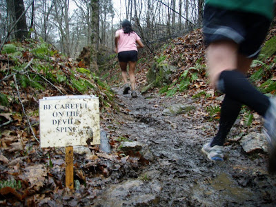
While some of the course looked like this...
Umstead Trail Marathon 2012 Sloppy Single-track
...Most of it looked like this
(ignore the jovial dork on the left).
These two photos courtesy of the awesome Shannon.

Oh, yeah, that's right; it's hard to run twenty miles!

Granted, I was encouraged by the fact that I managed to complete those long runs (up to 24.96 miles, thank you very much). But, I was discouraged by how much I loathed those last few miles of each long run. And, then, being a breath away from puking at the end of those runs didn't do much for my self esteem either. What the hell was I thinking?

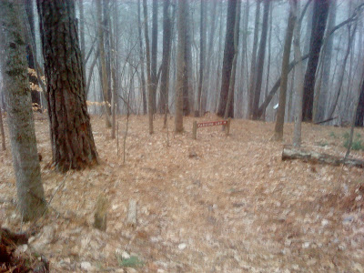
Ah, yes, it's Umstead!

So, I didn't feel all that comfortable with my training when taper time arrived. I would have liked to fit in a couple more 20-mile runs. A long tempo run, or some similar speedy distance thing would have been nice, too. But, I did what I could without breaking myself. So, I arrived at the race in the mud and the mist thinking positively.

For instance, after retrieving my packet from the registration table, I thought about how the revelation of the bat as this year's mascot on the eve of the race really made my day. What a cool animal for a trail race emblem! The mascotology analysts really nailed it this time.

Another pre-race positive, in my point of view, was the exceptional weather we had. Rain on a trail before and during the race just makes it so much more fun, I say. Playing in the dirt is one thing. But, turn that dirt into mud, and you've got ideal conditions for sloppy awesomeness!

Of course, when it rained lightly on me around mile nine, I remembered that I'd neglected to follow my own rain running advice with regard to the use of band aids. Luckily, there was no bleeding, just a little rawness for the remainder of the day.

Hilly

The course description on the race website explains that the Umstead Marathon course is hilly. They're not joking.
Umstead Marathon Course Elevation

Sure, the elevation gain is less than 1,000'. But, those hills keep on rollin'. And the final few just before the downhill finish can be murderous. Umstead Marathon veterans talk about the return along Cedar Ridge (miles 22-24-ish) with disdain. And, there's a good reason for that.

I consistently cursed the hills in those last six miles. And, although I knew it'd be smart to walk them, I was also afraid that stopping my running momentum just once would result in me walking the rest of the course.

But, hills certainly aren't all bad. If you've got the fortitude and stamina, you can plod up the big ones on Turkey Creek to reel in a competitor or two. And, if you have a penchant for stupidity, you can have a real blast letting gravity and rapid leg turnover take you down those same big hills on the return trip.

Remember when you were a kid riding your bike so fast down a hill that you knew you'd lose control and crash at any moment? Turkey Creek hills can be kind of like that. Luckily, I didn't slip and suffer any injuries. I'm sure my carelessness here contributed to my lack of energy later in the race, though.

Around mile 19, on the long, subtle climb up from Turkey Creek Trail's intersection with Cedar Ridge Trail, I started to feel the fatigue. I played leap frog with a couple of folks, passed a few, lost to a few.

One particularly clever fellow played leap frog with me from mile 24 to 25-ish as he walked the hills while I shuffled up them. Then, he'd skitter past me on the downhill or flatter terrain. I loved that episode in the race.

(Fortunately, the wise walking fellow moved so far ahead of me shortly before mile 26 that I didn't have to pretend that I'd have a chance of beating him. Good for him)

Not so Chilly

The previous week's warm weather clashed sharply with the overnight storm system that loosened the Umstead soil so well. It was humid and barely brisk at the start of the race. So we gathered comfortably in our colorful play clothes outside the lodge in anticipation of the start.

I had the opportunity to talk with famous runner bloggers Barefoot Josh and Der Scott who offered me some fantastic tips about fueling before you need it. This was enormously helpful to me during the race. And, everyone's favorite run-down speed demon, Anthony C. stopped by in his bike gear to wish us good luck.

For the first time, I got a sense of that trail runner camaraderie that more socially acclimated people than I know so well. And, that sort of thing really helps lift one's spirits before and during a race. I mean, I'm happy to relay the ol' "good job" to anyone passing by. But, imparting those tired, overused words to a friend turns out to be more of a benefit to me than the other party, I think. Maybe that's just because I'm so socially inept.

With blood sugar low after my 3:55:50 finish, I felt cold and hungry. So, I scarfed down some calories while chatting with Josh about his awesome 9th-place finish. Then, I put on my jeans and jacket while waiting to congratulate Scott on his new personal best for this race.

The sense of triumph in the air was almost palpable as I watched each runner carry themselves to the finish line. The rain had definitely stopped for the day. But, the temperature remained cool and pleasant. So, hanging around and enjoying that foresty Umstead smell while snacking on Moe's burritos, cookies, and bananas made for a marvelous post-race recovery time.

I can definitely understand why so many people love this race. And, I'm glad to count myself as one of them now.

Gear

Inov-8 f-lite 195 for the Umstead Trail Marathon 2012The weapons of choice for this Umstead adventure were the Inov-8 f-lite 195s and a new pair of Injini socks. Both items suited me just fine over those 26.2 miles.

I woke up that morning feeling a little dry in the mouth. So, I opted to carry water with me. I used a new Ultimate Direction ten ounce hand-held bottle, which was okay.

It was nice to have the bottle while I sipped those Honey Stinger gels between miles four and ten. But, then the bottle was empty after that. And, I didn't feel like stopping to fill it. So, I was just carrying an empty bottle for roughly sixteen miles. I'll probably leave the bottle at home next time. The aid stations were sufficient, I'd say, especially in that weather.

Thanks

The race directors, voluteers, and spectators were supremely awesome! Thank you all so much for standing around in the rain to ensure that our race went as swell as possible.

The aid stations lacked for nothing. And, the biker people were never far away. There's just something about a bright, yellow jacket on a gray, Umstead trail that warms a tired runner's heart, right?

The Cedar Ridge biker fellow had some especially encouraging things to say about training and form while I ran by. And, that was just awesome!

So, thanks so much, Umstead Marathon support team!

And, thank you, dear reader, for scrolling all the way to the bottom of this race report!

Thursday, March 1, 2012

Running in the Rain: Suggestions for Umstead Marathon Runners

If you're planning to run the Umstead Marathon this Saturday, and you're trying to find ways to divert your attention from running by thinking of things indirectly related to running—such as the weather—then you've probably checked the Raleigh weather forecast at least twice already. And, you would have seen forecast imagery that looks like this.

East Coast 3-3-2012 forecastThe green glob spanning much of the East Coast represents rain, folks. And, unless the local meteorologists are conspiring against our collective Umstead state of mind, then we can expect to see some precipitation during the race Saturday morning/afternoon. So, let's examine some helpful tips for running in the rain to prepare us for this 26.2-mile adventure.

First of all, we must respect and acknowledge that certain weather conditions, "inclement weather" to be precise, will require the race directors to "cancel" the marathon. (My assumption is that lightning will be the determining factor) Online dictionaries define "inclement" with words like stormy, severe, tempestuous, and a bunch of other subjectively vague terms.

But, whatever the directors decide Saturday morning, we must understand that things would go very badly for them indeed if some poor runner were zapped by lightning while they, the race directors, were the responsible parties.

Now, if the race is "canceled" due to inclement weather, I see no reason why we can't just have a fun run of sorts. And, if the directors wanted to leave the pint glasses and trophies in a box at the finish line for us, that would be fine.

Anyway, legal stuff aside, here are those rain running tips for Umstead:

Leave your race shoes in the car until race time. Walking around in the mud while it's raining is a good way to make your feet unhappy before you force them to carry you for 26.2 miles.

Sure, you and your feet know that they're going to get wet anyway if it's raining. But, feet generally like to stay as dry as possible for as long as possible. So, if you start out with soggy, muddy shoes right away, you can be sure that your feet are going to find a way to tell your mind that you're an asshole. And, when your mind hears that kind of talk from your supporting body parts at the beginning of a marathon, you're pretty much screwed.

So, walk to the registration table barefoot if you have to. And, just before the start time, go dry off your feet and retrieve your shoes. If your car is parked far away, carry your shoes and a towel in a plastic bag while you mull about the starting area.

muddy shoe printChoose footwear wisely. Single-track trails can be slippery when wet. They're riddled with smooth rocks, loosely fallen foliage, and roots. These are all things that can be even more precarious with rain. So, footwear capable of traversing such slippery stuff is ideal.

However, single-track trails make up roughly 19% of the total marathon course. So, don't go overboard with the shoe selection debate. Bridle trails with crushed gravel are not so slippery when wet. And, unless there's a deluge eroding whole pieces of Turkey Creek Trail away, you won't need the Bare-Grip 200 to get you through a rainy Umstead landscape. Just be careful on the single-track stuff.

Don't let the puddles mess with you. I had the good fortune to run on Loblolly during inclement weather a few months ago. And, aside from the cracking sounds of thunder and brief periods of hail, the things that made me run faster than I'd intended were the precariously positioned puddles that formed suddenly along the trail.

It's reflexive to try and leap over a puddle or evade it as best we can. And, that requires some extra energy. But, really, if your already soaked, the best thing to do is run right through! Don't waste your energy unnecessarily during a marathon.

(Again, this is more of a single-track issue. So, most of your race will not be affected by puddles. But, if there are puddles in your path, try to conserve your energy)

Dress for the temperature. Sure, rain makes the temperature colder. But, if it's 60 degrees and raining, you do not need your jacket while you run a marathon. You'll overheat or find yourself stuck carrying a jacket for a few miles. And, why would you want to carry a jacket during your race? Why?

Wearing a hat with a brim keeps the rain out of your eyes. Not much else to say about that unless you wear the hat backwards.

The techiest technical fabric in your running wardrobe will be your friend. So will things like band aids, Vaseline, and Body Glide.

Wetness and chafing go together all too well, I'm afraid. And, that cotton blend just isn't going to cut it if you want to avoid chafing.

Don't count on running your fastest race if it's raining. Muddy trails, potentially strong winds, and, um, rain do a lot to slow runners down. So, just take care of yourself out there. Don't kill yourself. Don't keep looking at your watch or Garmin. Running in the rain is a lot of fun, actually. And, even if this doesn't turn out to be your fastest marathon, it might be the most fun yet!

See you on Saturday!

Thursday, February 23, 2012

Richland Creek Trail Review or: The Other Side of Loblolly

Richland Creek Trail

Trail Location:Richland Creek Loblolly Trail
Schenck Memorial Forest | Raleigh, NC

Trail Distance:
4.3 miles (out & back)

Trail Difficulty:
Easy

Run Map >>

When I run Loblolly, I typically do so during my lunch hour. So, I lack the extra time to explore beyond the gate just past the Umstead border. I know there's more trail there. I've read about it's extension through Schenck Forest and all the way to the RBC center.

But, there seems to be dearth of info about Schenck Forest's trails on the Web. Click that Schenck Forest link to the left. And, you'll see what I mean. So, I've been hesitant to devote the time to see where else I could go from the edge of Loblolly.

Then, I noticed that the handy-dandy course plotting map on RunningAhead had the Richland Creek Trail mapped as if it were a regular old city greenway. So, I could finally see where it ended and how to get there without having to first run the entire length of Loblolly inside Umstead.

So, the other day, I drove the four minutes from my office to the RBC Center trail head and went for a run.

Running the Trail

Cross the little creek
Yes, you should cross these rocks and the water trickling between them.

If you start from the parking area outside the RBC Center, the southeast end of the trail, your first few steps will be on a paved section of greenway. This paved path will abruptly end in front of a chain link fence. And, as you approach, you might be wondering what the hell is going on.

Don't worry. You'll see that a subtle path through the grass to the left continues the trail. Follow this path along the fence and cross any rocky ditches or bodies of water you happen to find. (This is the general rule of thumb for this trail, by the way: When in doubt, cross it)

Cross the sidewalk
Do not follow the sidewalk or cross the bridge. Keep going into the grass.

You'll come upon another piece of paved greenway and follow it under Edwards Mill Road. As you emerge from the tunnel, you'll want to ignore the fancy little footbridge at the end of the sidewalk. That takes you nowhere you want to go. Cross into the grass again and scramble over another rocky ditch.

This next section of wide, grassy trail is definitely prone to flooding. Large puddles will wait for you if there's been rain within the past 48 hours. Consider your footwear carefully before embarking on this run.

A reassuring trail marker directs you through another tunnel. This one might be a little forboding, though, because it's at the same level as another tunnel right beside it, a tunnel full of water. Just look before you start running through, okay. You'll be fine. There are lots of lights.

Cross the sidewalk
View of the Wade Ave. Tunnel from the northeast side. Careful on that ledge.

Once you complete the scary tunnel run, you'll want to be careful as you traverse the ledge that leads you over to the rest of the trail. There's another little creek to cross here, too. (See the lower left of the photo)

The Richland Creek trail continues as a wide, puddle prone path along the creek with westbound Wade Ave. a few meters away. This portion is flat and easy to navigate. And, you'll feel pretty comfortable if not a little unsure about where you're headed.

Fortunately, the path veers to the right a bit. And, you'll see a tree with white paint on the trunk. And, that's gotta be some sort of trail marker, right? So, you continue your run onto a narrower, more single-track-like section of the trail.

Richland Creek Trail along Wade Ave.
Flatness punctuated with puddles. Richland Creek turning single-track
Richland Creek Trail becomes narrower here.

Richland Creek Trail's single-track portion skirts along the western edge of Schenck Forest, leading you over subtly technical terrain with a mild hill here and there. Most of your footing will be rather steady with relatively few rocks and roots to dodge.

Actually, I found the spots of mud to be the most challenging aspects of this trail, since my rather smooth-soled road shoes were especially prone to slipping in the squishy, wet dirt during this run. I'm not used to slipping.

A Loblolly and Richland Creek Trial intersection
This is how the "Loblolly" intersection will appear to you if you're heading southeast from Reedy Creek Road. Continue to the right if you're intent on following the Richland Creek Trail to the RBC Center.

At one point in the trail, there's a somewhat confusing array of trees and matted leaves on the ground, making the trail a tad tough to discern. So, you might find yourself turning around in circles and wondering which way to proceed. Look for the city greenway trail marker.

Also, a bridged intersection with a sign pointing two directions for "Loblolly" might inspire a degree of doubt in your navigation abilities. Ignore the sign and just concentrate on where the creek is pointing. So, if you're heading northwest, continue northwest, not northeast. Reverse those instructions if your heading southeast.

My Favorite Features of the Richland Creek Trail:Richland Creek Trail Mud

  • That tunnel under Wade Avenue is cool, albeit a bit dangerous at night, I suppose.
  • Water crossings and mud are always nice features of a trail.
  • The proximity of the RBC Center trail head to my office is definitely nice.
  • A good distance for an easy lunchtime run.

Features I Dislike:

  • The lack of trail maps within Schenck forest is disappointing. (Maybe there's one at the main parking lot. But, that doesn't help me here)
  • Hearing the cars on Wade Ave. while trail running isn't very appealing. But, that's the price you pay for urban convenience, I guess.
Richland Creek turning single-track
About as technical as it gets on Richland Creek Trail

Getting There

Easy! Take your favorite route to Edwards Mill Road and turn onto RBC Center Road. Watch for the parking lot on the left just before RBC Center Road intersects with itself. There's a greenway trail head sign on the little hill at the corner of this parking lot. Access to this lot may be challenging when the RBC Center is hosting some sort of event.

Alternatively, you could park (at your own risk) in one of the office building lots near the area I just described. The paved greenway along Edwards Mill Rd. is easy to spot. And, you should be able to find the tunnel under Edwards Mill pretty easily.

If you want to tackle the trail from the northwest end, I can't recommend a parking spot on Reedy Creek Rd. Maybe some of you know about such a spot. But, I don't.

Or, if you have oodles of time, why not tack the Richland Creek Trail onto your next Loblolly run through Umstead? Sure, I couldn't really tell you at this time what's between Umstead's boundary and Reedy Creek Rd. I haven't traveled that part of the trail yet. But, lots of people do, right? And, it's not that much further.

Richland Creek turning single-track
Richland Creek Trail from the Reedy Creek Rd. Trail Head

Summary

So, with the exception of a couple of questionable direction markers on the trail, the Richland Creek Trail takes you on a pleasant trek from the RBC Center to Reedy Creek Road (and back if that's your plan). There are few technical trail challenges and only two or three hills to climb. Plus, the view of the creek for much of the journey is rather nice.

The Richland Creek Trail Map and Elevation Profile.

This is the map I created with RunningAhead's map tool, which already had the trail plotted as a greenway. So, it should be fairly accurate. As you can see, there's not a lot of climbing on this trail:
Richland Creek Trail elevation and map

Richland Creek Trail along Wade Ave.
Plenty of creek views

More Triangle-Area Trail Reviews >>

Thursday, December 22, 2011

Umstead Trails vs. Mountains to Sea Falls Lake Trails

This is not going to be a very scientific comparison of the single-track trails at Umstead State Park and the Mountains to Sea Trail at Falls Lake. At the time of this post, I have yet to run all 37.5-miles of the Falls Lake Trail.

Plus, I'm writing this post without doing much planning, because I am essentially inspired by a question Diana posed in a comment on another post. And, as I responded to that comment, I realized I could really just make a blog post out of my answer, since I'm so wordy and all.

So, here's my totally subjective, off-the-cuff, trail runner's perspective on experiencing the Umstead trails and the MST at Falls Lake.

Most runners would probably say that the two trail systems are pretty similar. And, most runners would be right. I mean, we're not living in the mountains here. And, Falls Lake is roughly a speedy 15-minute drive from Umstead. So, aside from that lake; the terrain, flora, and fauna are largely the same.

Umstead State Park Company Mill Trail
Umstead Trails Have Rocks

But, if you really wanted to be particular about differences, some people would say that the hills at Umstead are a little more severe than the ones at Falls Lake. By "severe" I mean that I'm more aware of a significant hill climb when I'm running Company Mill or Sycamore than I am of the hill climbs at Falls Lake. And, by "aware" I mean that the hills seem more challenging at Umstead.

Falls Lake MST Trail
Falls Lake Mountains to Sea Trail
(not as rocky)

However, I should quickly add that there seem to be more hills at Falls Lake. But, the Falls Lake MST hills feel more like they're helping me roll along the trail, up and down—like floating on a small boat over slightly rough water. But, take out the floating feeling, because you're actually running. And, running is not like floating (Except in those still photos that some race photographers manage to capture. And, even then, running only looks like floating. I mean, you know perfectly well that running is not what you do to feel floaty) Anyway, the frequent hills at Falls Lake are fun!

Moreover, if you are the type to count rocks, I'd bet that you'd find more rocks at Umstead than you would at Falls Lake. There are some rather large rocks at Falls Lake, though, especially along Section 2. So, don't leave your trail shoes and strong ankles at home. I'm just saying that there are most likely a larger collection of rocks along the Umstead trails.

Roots are equally challenging to traverse and see on both trails.

If you like stopping to admire scenic vistas or forest animals, then the Falls Lake MST would offer the best opportunities for those trail running extras. Umstead is pretty much in the middle of Raleigh and right next to the airport. So, animals that have managed to adapt to the bustling human activity surrounding the acres comprising Umstead are most likely not interested in letting you look at them for very long. Although, the deer seem to like looking at people there.

On the other hand, Falls Lake is on a gigantic lake, which pretty much guarantees at least a few scenic vistas. And, the animals at Falls Lake, in spite of the fact that they're allowed to be hunted, show up more often in varied forms. (Once, I almost collided with a deer on the path at Falls Lake)

Similarly, I encounter more people walking their awesome dogs at Falls Lake, while I usually have to run around larger groups of people at Umstead. This discrepancy is probably due to the times of day and days of the week that I choose to run the trails.

Some runners might like to know that running between the various sections of the Falls Lake MST usually requires traveling along the wide shoulders of various roads for a few meters. This isn't a big deal. But, if you prefer to go to a trail so that you can feel secluded from cars until you decide to leave the trail, then Umstead will be a better choice.

Okay, I've covered a few major points that come to mind in this Umstead vs. Falls Lake MST analysis. Let's sum up:

Falls Lake MST has...

  • More frequent but (mostly) smaller hills
  • Forest animals and scenic vistas you'll remember after the run
  • Necessary encounters with roads (oh, and backyards of private residences)
  • A lake
  • More frequent, friendly encounters with people and awesome dogs
  • Awesome trails

Umstead has...

  • Fewer but bigger hills to consider
  • More rocks over a wider area
  • Less wildness and lake scenery (but the creeks are great)
  • But, strangely, more of a sense of seclusion from cars and stuff
  • Larger groups of people on certain days
  • Awesome trails

So, that's me being nitpicky about the differences between Umstead and Falls Lake trails. But, really, I love both of these places! Seriously! My only preference for one over the other on a given day is governed by my geographic proximity (Umstead is closer to work. Falls Lake is closer to home)

Friday, March 25, 2011

FY(effin')I: Run/Walk/Bike for Umstead
April 16, 2011

Umstead owlAs I was leaving the Reedy Creek entrance parking lot this afternoon—after a fantastic run on Company Mill—I grabbed a brochure advertising the Walk/Run/Bike for Umstead event. I hadn't yet seen information about this opportunity to support one of the area's best parks. So, I figure it won't hurt to spread the word.

Here's my summary:

What:

Choose a 4-mile walk/run on a park trail, a 4-mile beginner mountain bike tour, or a 10-mile intermediate mountain bike tour. Enjoy live music along the trail and on the main stage. This is a community event for the appreciation, use, and preservation of William B. Umstead State Park. Funds raised will be used for controlling invasive plants, protecting native wildflowers, environmental education, and land acquisition.

When:

Saturday, April 16 (rain or shine)

Where:

A private farm on Reedy Creek Road next to William B. Umstead State Park. The Walk/Run/Bike route starts and ends at the meadow and goes along the gravel, multi-use trail in Umstead State Park.

Now go read more about it on the Umstead Coalition's event page >>

Tuesday, February 15, 2011

Trail Review: Sycamore Trail at William B. Umstead State Park

Sycamore Trail


Trail Location:Umstead Park Map
William B. Umstead State Park | Raleigh, NC

Trail Distance:
7.2 miles (out & back)

Trail Difficulty:
Moderate

Elevation profile & map >>
See the Umstead park map >>

If you only run one trail in Umstead State Park, make it the Sycamore Trail. The longer distance and slightly rockier terrain make this course one of the most enjoyable in Umstead. Sure, I love running on the Loblolly or Company Mill trails, too. But, Sycamore is special to me, more appealing when I have the time, just by a hair. I mean, don't get me wrong, all the trails in Umstead are great. Seriously. Don't run just one.

Moving along...

As you'll see on the park map, the Sycamore Trail follows a lollipop-style route from the northern section of the park, just south of the visitor's center. The trail eventually takes you past Sycamore lake and along Sycamore Creek before leading you back to the trail head.

trail head of the Sycamore Trail at Umstead
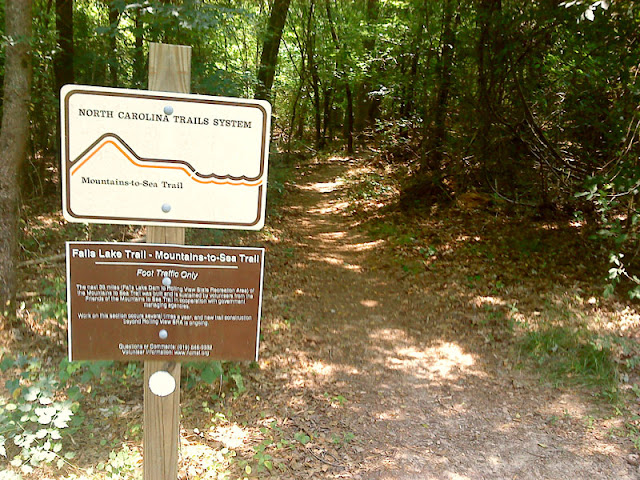
Creating your own mish-mash of a trail run by including other Umstead trails on your route is simple, because Sycamore intersects other traveling paths at a couple of great points. There's the Pott's Branch loop, which is short but nice when you want to tack on a couple more miles for the day. Or, you could hop onto the bridle trail and skip over to Company Mill for a decent long run. There are so many possibilities.

If you're like most park visitors, you'll enter Sycamore Trail from the North. From there, the trail begins with a quick descent and a couple of switchbacks before leading you to a bit of flatness along the creek. You'll cross the park road and continue along a wider, somewhat technical path with lots of pine needles under foot. The section gradually becomes more technical with roots and rocks testing your agility. And, the hills become a bit more intense, too.
Sycamore Trail at Umstead
Crossing the bridle trail, you'll keep going for a while until you reach a split. You can go left, which takes you up hill, or right, which takes you down hill. There is no wrong choice here. A sign indicates that the parking lot is to the left. But, just ignore it. You're not going to the parking lot. And, if you entered the trail from the north, it's certainly not the parking lot in which you parked your car.

starting to snow on the Sycamore Trail at UmsteadWhichever direction you choose to go, the terrain will be splendid. There are areas with plenty of rocks and roots and areas that let you take it easy for a while. There are hills. There are scenic flat pathways along the creek. There are certain spots that never seem to be free of mud. Sycamore does not disappoint.

Eventually, you'll find yourself approaching that familiar parking lot sign that marks the split in the trail. You've completed the circular portion of the course. And, now, you get to return along the same route on which you started with a different perspective. Depending on your level of expectations, you may or may not be glad to know that the toughest hills are behind you.
Apologies for the poor quality of these photos. It was starting to snow and sleet at the time.

My Favorite Features of the Sycamore Trail:running in snow on Sycamore Trail at Umstead

  • Rocky hills for ascending and descending
  • multiple switchbacks along hill sides
  • Contrast between flat, easy terrain and challenging, technical footing.
  • Most everything else

Features I Dislike:

  • 1 bridge with stairs

Getting There

You'll want to enter Umstead via the Umstead Parkway entrance off Hwy 70 (aka Glenwood Avenue). Follow the parkway to the end of the road, which will end in a parking lot. You'll pass the visitor's center and another parking lot on your way there. Don't be tempted to pull into the first parking lot you see. Go all the way to the end of the road.

Get out of your car and head east from the parking lot to the paved path that curves away, forming a circle, toward a couple of picnic buildings. Continue east for a few more meters until you reach the largest covered building. The Sycamore Trail Head will be to the left of it. Start runnin'!

This is important: If you need to use the restroom before starting your run, backtrack away from the trail head and make a right at the paved path's intersection. The restroom is between the parking lot in which you parked and the other one you saw on your way down the parkway. It's not far, just inconspicuous.

If you find yourself heading toward Umstead on Ebenezer Church Rd., it appears that you could access the Sycamore Trail by turning west onto Graylyn Dr. Follow it to a parking lot somewhere in the middle of the trail's out-and-back portion. I wouldn't want to park here, though, because I'd feel like I was starting the run in the middle. It'd feel less complete this way, don't you think?
by the creek on Sycamore Trail

Summary

If you've already perused my other reviews of Umstead trails, you might be tired of reading the same thing: This trail is great. I love it. Umstead is awesome.

Well, I approach a trail run from a conceptual perspective. And, being the positive fellow that I am, I am often hard pressed to find fault with any trail in the woods. Perhaps this is due to my lack of experience. Yet, as redundant as my Umstead review series is, you should be glad to know that it's hard to choose a bad trail there.

So, Sycamore is the longer trail. And, for that reason, I think it offers just a smidgen more of an Umstead experience to the runner than the other two major technical trails (Loblolly and Company Mill) in the park.

I mean, there's no reason you shouldn't run every trail in Umstead. But, if you're in Raleigh for a day with time for just one trail run, choose to run on the Sycamore Trail.

The Sycamore Trail elevation profile.
Check out an interactive map, too >>

check out the Sycamore Trail elevation profile

advertisement

Related Posts Plugin for WordPress, Blogger...